Although the bottom
topography on the Faroe Shelf (< 400 m) is mapped in great detail (using
echosounders, trawl, dredges, etc.), studies of benthic communities and bottom
substrate types are more limited in their spatial extent. For example, habitat
investigations conducted as part of the BIOFAR programme, revealed six major benthic
assemblage types occurring at varying depths between the shallow sublittoral
and 500 m.
Important sandeel habitat comprising coarse sandy sediments are generally located in areas shallower than 150 m exposed to medium/strong tidal currents. A Modiolus community associated with coarse sediments, a habitat for cod feeding, is widely found at depths < 100 m. At 300–500 m depth vulnerable marine ecosystems (VMEs) consisting of cold-water corals and large sponge grounds (e.g. Lophelia reefs and Geodia sponges) have been discovered. These deeper‑water VMEs have been subject to bottom‑trawling impacts in the past, but since the 1990s they have been protected from bottom fisheries. Indeed, a total of 60% of the Faroe Plateau at depths of < 200 m is now closed to bottom trawling to protect coral reefs and other important habitat types such as fish spawning grounds (see figure 12 below). The waters within the entire 12‑nautical mile zone on the Faroe Plateau are also closed to all types of bottom trawling, except for a period in summer when limited trawling for flatfish by smaller vessels is permitted.
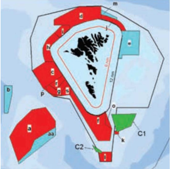
Figure 12: Fishery protected areas on the Faroe Plateau. No trawling; red areas, closed to trawlers all year; blue areas, seasonal (e.g. spawning) closures; green areas (C1, C2): coral areas closed to bottom trawlers.


