The seabed of the Celtic Seas ecoregion is primarily composed of sediments (Figure 13). Coarse sediments cover most of the Malin Shelf. Coarse sediments are also the main habitat type found in the Irish Sea, along with patches of mud to muddy sand and rock. Sandbanks are prominent features off the southeast coast of Ireland. Coarse sediment, sand, and mud to muddy sands are found in equal measure in the Celtic Sea. Areas of rock and hard habitats are present in the northern (west of Shetland Islands) and inshore (west and south coasts of Ireland, southwest England coastline) parts of the ecoregion. Mud to muddy sand habitats dominate the deeper, offshore areas.
The soft sediments are characterized by burrowing megafauna. This includes sea pens and commercially important species (e.g. Norway lobster) as well as macrobenthos such as deposit-feeding polychaetes. The coarser sediments are habitats for commercially important shellfish species, e.g. Pecten maximus and Aequipecten opercularis; and to sensitive species and habitats, e.g. maerl, brittle star beds, Modiolus modiolus beds, and Atrina fragilis. The nearshore rocky habitats are characterized by algae and epifauna; however, some areas of rocky habitat in deep waters in the northern part of the region are characterized by hydroids, bryozoans, and cnidarians such as Eunicella verrucosa and Swiftia pallida. Structural changes in benthic communities and declines in native species have been observed as a result of the more than 200 non-indigenous and cryptogenic (unknown origin) species recorded in the region as a result of shipping, coastal water currents, and aquaculture.
There are 3 091 records of VME habitats and 9 278 records of VME indicator taxa in the Celtic Seas ecoregion below 200 m in depth. VMEs in regions shallower than 200 m may exist but are not recorded in the VME database. All records for the VME habitats come from the northwest of Scotland, west of Ireland, and the Celtic Sea, while no records have been made for the Malin Shelf and the Irish Sea. However, a small portion of VME indicator records do arise from the Malin Shelf and the Irish Sea.
VME habitats include anemone aggregations, cold-water coral reefs, coral gardens, deep-sea sponge aggregations, sea pen fields, stalked crinoid aggregations, tube-dwelling anemone aggregations, and xenophyophore aggregations. VME indicator taxa recorded are: anemones, black corals, cup corals, gorgonians, sea pens, soft coral, sponges, stony corals, stylasterids (lace corals), and xenophyophores.
OSPAR threatened and/or declining habitats
Additional recorded occurrences (i.e. < 200 m depth) of Sabellaria spinulosa reefs in the ecoregion are concentrated around the west coasts of England and Wales, with a more scattered distribution around Scotland and Ireland (Figure 9). Modiolus modiolus beds occur patchily in the Irish Sea.
Impact of fishing
Bottom fishing is the single most important impact on the seabed in this area. The actual impact of bottom trawls depends on the type of fishing and its intensity, as well as on seabed sensitivity. The impacts on seabed habitats and associated biota by these gears in the ecoregion have been assessed by combining data on benthic species-specific longevity, depth, habitat characteristics, gear-specific characteristics, and fishing intensity to generate a map of potential benthic impacts (Figure 16).
The benthic sensitivity layer is based on two separate analyses. The sensitivity layer for the Irish Sea is based on epifauna data from the international beam trawl survey (BTS), and the sensitivity layer for the remaining Celtic Seas ecoregion is based on epifaunal data from the Irish ground fish survey.
In the ecoregion, many of the heavily impacted areas are due to Nephrops trawling and otter trawling for mixed demersal fish, including monkfish, along the continental shelf edge. In the absence of an agreed impact threshold, to categorize areas of low impact, a 0.2 impact level was arbitrarily chosen for illustration purposes.
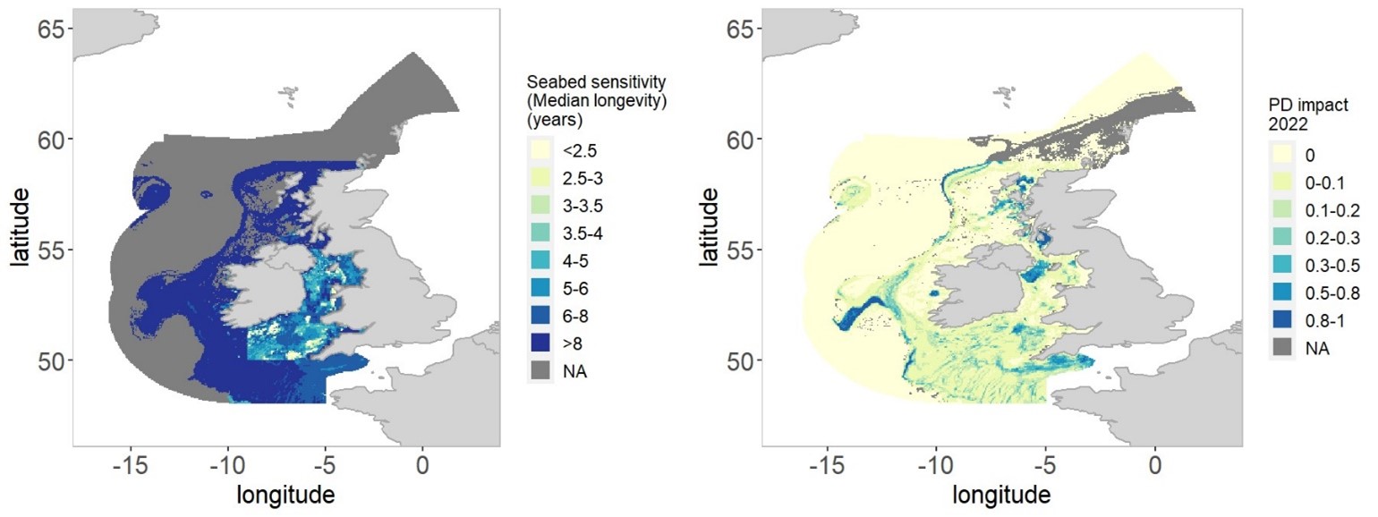
Figure 16: Assessment results
for the Celtic Seas ecoregion in 2022. Left: Seabed sensitivity (median
longevity in years). Right: bottom trawl impact (PD-impact indicator). n/a =
not analysed/assessed due to data unavailability for cells > 200 m
depth.
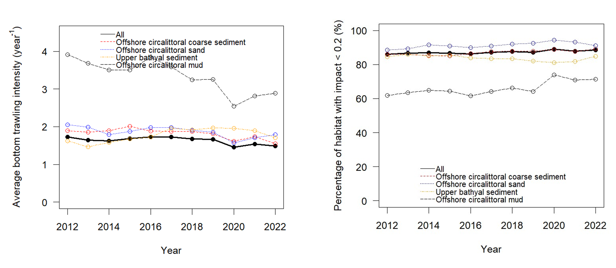
Figure 17:Temporal trends for the Celtic Seas Ecoregion for the four most common
habitat types and whole ecoregion. Left: pressure presented as average bottom
trawling intensity (per year) over time. Right: fraction of the area below 0.2
threshold impact over time. References to habitat types follow the EUNIS
classification, comprising a zone and substrate type (EUSeaMap, 2023). Spatial
distributions of these habitat types in the Celtic Seas Ecoregion are
shown in Figure 13.
The sensitivity of a habitat is determined by the lifespan of the benthic communities in undisturbed conditions. A habitat with a higher fraction of longer living species would be considered sensitive compared to one with a higher fraction of short living species. The sensitivity of the Celtic Seas ecoregion is highest to the west of the ecoregion closer to the shelf. The Irish Sea is less sensitive (Figure 16).
The depth zone 0–200 m in the entire ecoregion was fished with bottom trawls 1.3 times on average in 2022. When bottom fishing pressures are evaluated at c-square scale, 66% of the grid cells are at least partly trawled in the depth zone 0–200 m and 59% in 200–800 m. Thirty-nine percent of the ecoregion is deeper than 800 m and is not currently trawled.
Offshore mud represents 6% of the Celtic Seas seabed and is mainly affected by Nephrops fisheries. It experienced the highest fishing pressure and impact compared to other habitat types (Figure 17). Overall, the fishing intensity in offshore mud has decreased in recent years.
Offshore sand sediment represents 12% of the ecoregion. It is the second most impacted habitat type, and fishing intensity has been relatively stable since 2012.
Detailed information on Celtic Seas seabed pressure and impact indicators is provided in the WGFBIT 2024 report


