The benthic habitat type of the Greater North Sea is predominantly characterized by soft sediments (from muds to gravel beds; Figure 14). The spatial distribution of habitats follows gradients with respect to depth and latitude. The relatively shallow southern North Sea (0–50 m) is subject to greater natural disturbance because of wave and tidal effects giving rise to relatively coarse seabed sediments, for example the Dogger Bank and parts of the Southern Bight. Further north, beyond the Dogger Bank, mud content increases, as observed in the Fladen Ground at depths of 100–150 m and in the Norwegian trench at depths of 400 m. Coarse gravel and rock habitat types are predominately located in the English Channel.
he combination of depth, nearbed hydrodynamic conditions, and sediment types give rise to a large diversity of benthic communities within the ecoregion. Nearbed hydrodynamic stress is an important determinant of the species composition of benthic communities. High nearbed tidal forcing results in the transport of sands and fine gravel which act as natural stressors on the benthos, favouring benthic organisms that have specific traits adapted to such conditions (e.g. relatively short‑lived and fast‑growing species), whereas more hydrodynamically stable conditions with low levels of nearbed stress favour a greater diversity of life strategies. More locally, especially in the southern part of the North Sea, seabed geomorphological variations create localized habitats which can favour disturbance-resistant and long-lived species.
Impact of fishing
Bottom fishing is the single most important impact on the seabed in this area. The actual impact of bottom trawls depends on the type of fishing, its intensity, and the seabed sensitivity. The impacts on seabed habitats and associated biota by these gears in the ecoregion have been assessed by combining data on benthic species-specific longevity, depth, habitat characteristics, gear specific characteristics and fishing intensity to generate a map of potential benthic impacts (Figure 15). In the ecoregion, the Skagerrak and Kattegat seabed show high fishing impacts, with some other highly impacted areas scattered in the central North Sea and the Channel. In the absence of an agreed impact threshold, to categorize areas of low impact, an impact level of 0.2 was arbitrarily chosen for illustration purposes.
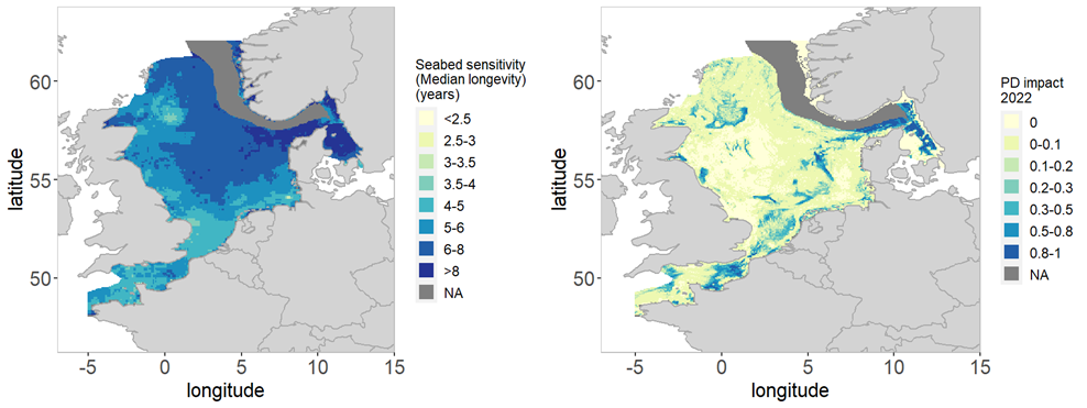
Figure 15: Assessment results for the Greater North Sea ecoregion
in 2022. Left: seabed Sensitivity (median longevity in years) and Right: bottom
trawl impact (PD-impact indicator). n/a = not analysed/assessed because of data
unavailability for cells > 200 m depth.
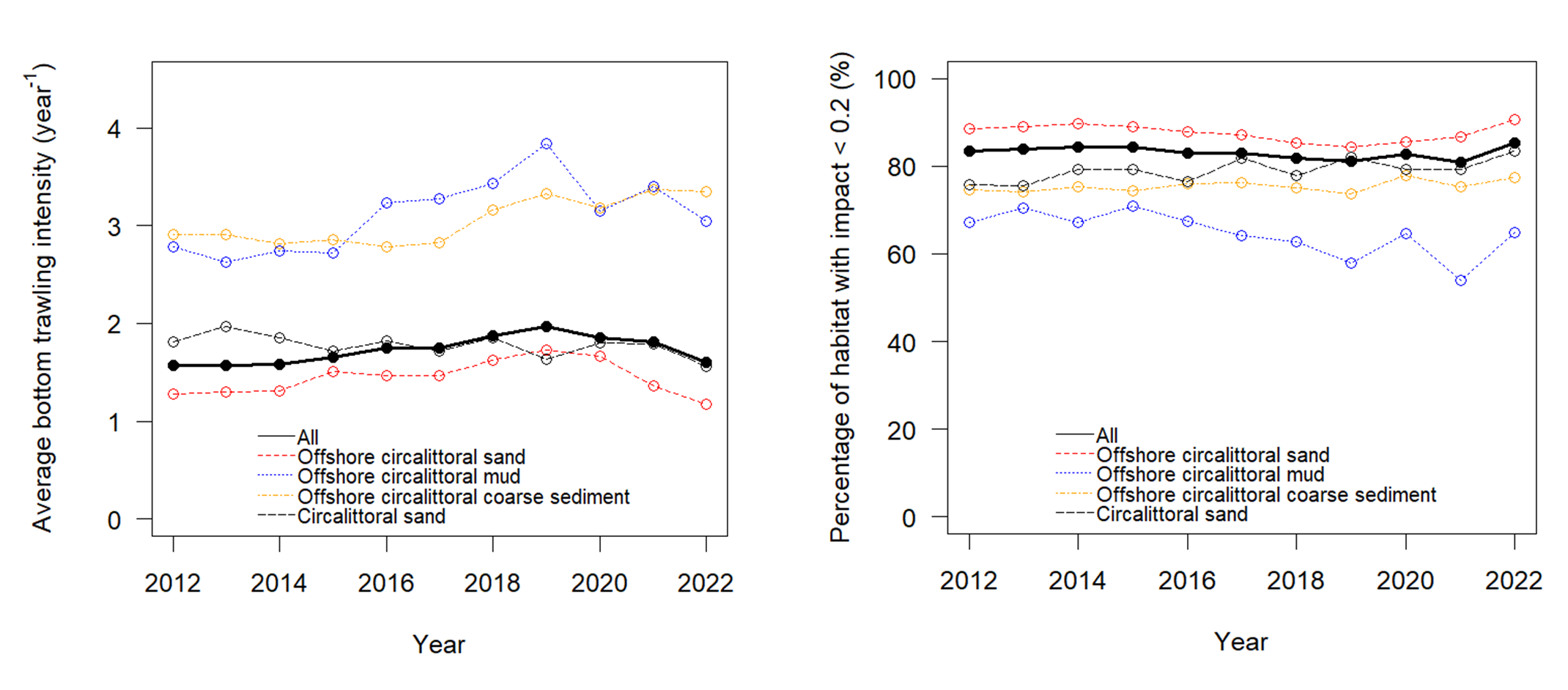
Figure 16: Temporal trends for the
Greater North Sea Ecoregion for the four most common habitat types and total
area. Left: Pressure presented as average bottom trawling intensity (per year)
over time; Right: fraction of the area below 0.2 threshold impact over time. References to habitat types follow the EUNIS classification,
comprising a zone and substrate type (EUSeaMap, 2023). Spatial distributions of
these habitat types in the Greater North Sea Ecoregion are shown in Figure 14.
The sensitivity of a habitat is determined by the lifespan of the benthic communities in undisturbed conditions. A habitat with a higher fraction of longer living species would be considered sensitive compared to one with a higher fraction of short living species. Sensitivity of seabead habitats is highest in the northeastern North Sea and Kattegat and lowest in the southern North Sea. The southern North Sea is less sensitive mainly the result of the high natural disturbance (Figure 15).
The depth zone 0–200 m in the entire ecoregion is fished with bottom trawls on average 1.7 times in 2022. When the bottom fishing pressure is evaluated at c-square scale, 70% of the grid cells are at least partly trawled in the depth zone 0–200 m and 27% in 200–800 m.
Offshore mud represents 15% of the Greater North Sea seabed and is mainly affected by Nephrops fisheries. Offshore coarse sediment represents 11% of the ecoregion; it is the second most impacted habitat type in the series, and fishing intensity has increased 'since 2016. In 2022, this habitat type experienced the highest fishing pressure and impact compared to other habitats (Figure 16).
Detailed information on the on the seabed pressure and impact indicators is provided in the WGFBIT 2024 report.
Except for patches of Ross worm (Sabellaria spinulosa) and horse mussel (Modiolus modiolus) reefs and scattered glacial erratic boulder fields, the North Sea contains limited biogenic and geogenic reefs. However, until the 1920s, dense oyster beds (Ostrea edulis) were widespread in parts of the southern central North Sea, creating diverse and productive benthic habitat. This biogenic habitat has, however, largely disappeared following the mechanization of fishing fleets. In this respect, the North Sea remains one of the most impacted shelf sea regions in the world. Other human-mediated disturbances on the seabed consist mainly of sand and gravel extraction and the growing introduction of offshore renewable energy structures such as wind farms, leading to potential smothering and habitat loss. Artificial hard substrates, such as hydrocarbon production platforms, wind turbines, and shipwrecks provide new different habitat types that can locally increase biodiversity. Sea grasses (Zosteraceae) used to be common off the coasts of the southern North Sea; however, their extent is now more limited because of the loss of shallow intertidal and delta areas.


